
Start Date: 01.04.2024 | End Date: 31.12.2026
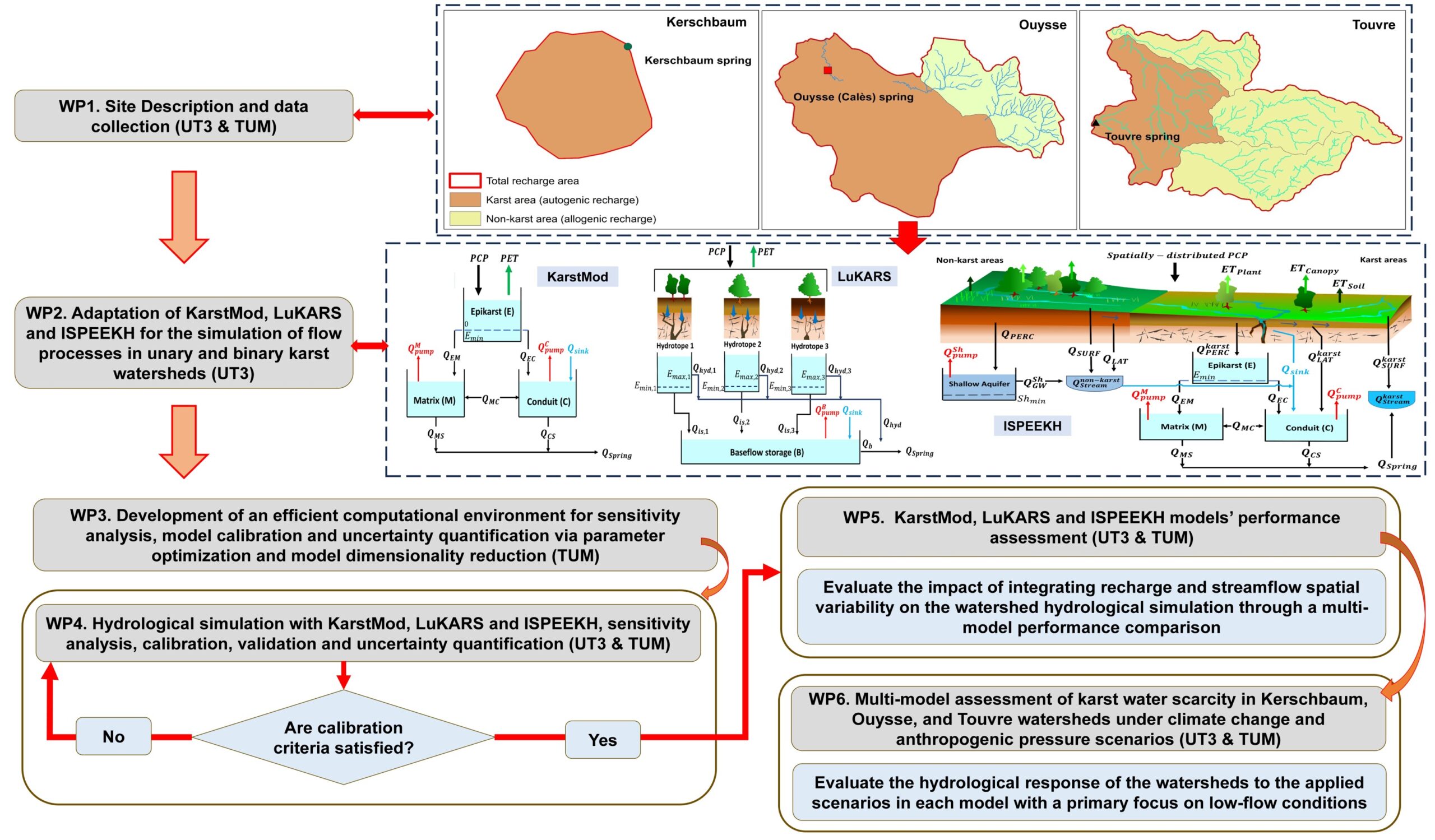
Karst aquifers, covering 15% of Earth’s surface and providing water to 25% of the global population, are facing a depletion stress due to increased water abstraction, land use change, and climate change, which is expected to further exacerbate water scarcity with predicted temperature rises of 1.5−4°C by 2100 (IPCC, 2023). Hydrologists use mathematical models to simulate watersheds and aquifers, understand their hydrodynamic behavior, and assess their response to climate change and anthropogenic pressure for sustainable water resource management.
Mathematical models applied in karst hydrology are classified as lumped or distributed based on their spatial discretization. Lumped models distribute infiltration to buckets and use transfer functions to relate input precipitation signals to spring discharge output. They are suitable for data-scarce and complex karst regions, providing an overview of the aquifer’s behavior and an understanding of its main features. However, by neglecting spatial variability, they may lack precision in capturing intricate flow patterns within karst aquifers, hindering accurate flow prediction and karst water resource management. Fully distributed models discretize aquifers into grid units and simulate a two- or three-dimensional form of the governing groundwater flow equation. They require detailed hydrogeological data and knowledge of the aquifer’s geometric properties, which can be challenging or impossible to acquire (Adinehvand et al., 2017; Chang et al., 2019; Fischer et al., 2018; Ghasemizadeh et al., 2012; Gill et al., 2021; Hartmann et al., 2014; Malenica et al., 2018). To alleviate the limitations of lumped and fully distributed models, semi-distributed models are proposed as a hybrid approach that bridges the gap between the two model classes by combining spatially distributed recharge with karst aquifer dominant flow components. This offers a promising solution for assessing flow spatial variability even with limited data on the karst structure (Yang et al., 2022). Yet, semi-distributed models can still carry a large number of parameters whereby their direct determination with necessary confidence makes them computationally costly. Surrogate models offer a reliable way to address this issue, commonly known as “the curse of dimensionality” (Verleysen and François, 2005) by fusion of computationally optimized versions of existing modeling pipelines, based on both lumped and semi-distributed karst models, with an effective dimensionality reduction technique capable of handling spatiotemporal hydrological data and providing the means to quantify the uncertainty.
To date, limited attempts have been made to simulate unary karst watershed hydrology using semi-distributed models that integrate spatially variable autogenic recharge based on land use and soil properties. The VarKarst model, developed by Hartmann et al. (2013), represents soil-epikarst flow processes, diffuse and concentrated recharge, and spring discharge using vertical compartments of unique soil and epikarst characteristics. Bittner et al. (2018) introduced LuKARS (Land use change modeling in KARSt systems), a lumped parameter model grouping areas of homogeneous land-use and soil properties in a karst watershed as independent spatial units called hydrotopes. Sivelle et al. (2022) compared the lumped reservoir-based model KarstMod (Mazzilli et al., 2019) and LuKARS in modeling spring discharge of three small karst catchments, showing mixed results whereby semi-distributed recharge with LuKARS improved discharge simulation performance for two catchments but provided no improvement for the third. Few researchers have modified the semi-distributed eco-hydrological model SWAT (Soil and Water Assessment Tool, Arnold et al., 2012) or integrated it with other models to better simulate karst watershed hydrology, but failed to reproduce key flow processes in spring-dominated karst watersheds, including flow non-linearity and the influence of allogenic recharge on spring discharge (AL Khoury et al., 2023a). AL Khoury et al. (2023b) modified SWAT+ (the latest restructured version of SWAT, Bieger et al., 2017) into the ISPEEKH (Integration of Surface ProcEssEs in Karst Hydrology) model by implementing three non-linear reservoirs of the epikarst-matrix-conduits system recharged by diffuse and concentrated flows based on karst geology. ISPEEKH was applied to simulate the water balance of a conservative karst catchment of the French Pyrénées and assess its hydrological response to land-use change scenarios of afforestation and deforestation. Previous research highlights the need for new numerical approaches that incorporate the recharge-discharge characteristics of both unary and binary karst watersheds and their collective dominant controls, including the landscape properties, interplay of partially overlapping surface drainage and groundwater basins in terms of autogenic and allogenic recharge, and influence of anthropogenic pressure. Thus, this project aims to further develop and optimize three mathematical models (KarstMod, LuKARS, and ISPEEKH) that conceptualize the aforementioned karst hydrological processes using lumped or spatially variable semi-distributed approaches. The three models will be applied to simulate and understand the hydrodynamic functioning of three distinct karst watersheds (Kerschbaum, Ouysse and Touvre) in Europe, assessing the impact of integrating recharge and streamflow spatial variability on the watershed hydrological simulation through a multi-model performance comparison. The models will then be used to assess the hydrological response of the watersheds to future scenarios of climate change and anthropogenic pressure, providing a systematic approach for improved water resources assessment and detection of water scarcity in karst watersheds.
Funding Organisation:
DFG-Einzelförderung / Sachbeihilfe (EIN-SBH)