
PD Dr. Luca Caracciolo
Address
Contact
Sedimentary Petrology: Research Vision
I am a sedimentary petrologist working at the intersection of fundamental Earth science and applied subsurface challenges. My research bridges modern sedimentary systems and deep-time stratigraphy, using quantitative provenance analysis to decode how tectonics, climate, and lithology shape the sedimentary record—and to predict how sedimentary systems will behave under specified boundary conditions. I combine academic research with industry collaboration, having worked across five continents from the Magdalena River to the Namib Sand Sea, from Permian red beds to Holocene deltas. In 2010 I co-founded the Working Group on Sediment Generation; in 2017 I established the School of Sandstone Reservoirs. My goal is to transform sedimentary petrology from a descriptive discipline into a genuinely predictive science.
Sedimentary petrology occupies a unique position among the geosciences: it is the discipline that decodes the compositional and textural information preserved in sediments and sedimentary rocks, transforming this information into quantitative constraints on the processes that shaped Earth’s surface—and its deeper lithosphere—through time. Every sand grain carries a signature of its source terrane, the crustal level from which it was exhumed, and the tectonic and climatic conditions governing its journey to deposition. Sedimentary petrology provides the analytical and conceptual tools to read these signatures—and, crucially, to predict them forward under specified boundary conditions.
This capacity to reconstruct both surface dynamics and crustal evolution places sedimentary petrology at a unique interface. Accretionary and unroofing processes—the progressive exhumation of deeper structural levels during orogenesis—are recorded in systematic changes in sediment composition through time. Detrital geochronology, thermochronology, and heavy mineral assemblages preserve the thermal and metamorphic histories of source terranes that have long since been eroded away. The sedimentary record thus serves as an archive of lithospheric evolution, providing constraints on processes operating at depths and timescales inaccessible through direct observation.
By quantifying orogen-basin relationships, exhumation pathways, sediment production rates, transport mechanisms, depositional facies, and diagenetic evolution, sedimentary petrology enables us to reconstruct tectonic and climatic signals in the geological record while simultaneously providing process-based frameworks for anticipating subsurface reservoir behaviour, landscape response to climate change, and environmental system trajectories.
My research vision is to develop predictive models of sedimentary systems that advance basic geoscientific knowledge while addressing societal challenges in climate change research, energy transition, and environmental sustainability. The future of geosciences lies in the deep integration of fundamental and applied research—and sedimentary petrology, by its nature, sits at exactly this interface.
Sediment Routing Systems and Sediment Generation
My research integrates Sediment Routing Systems (SRS) and Sediment Generation (SG) through Quantitative Provenance Analysis (QPA). This integration reflects a core insight of modern sedimentary petrology: that the composition of a sediment is not merely a fingerprint of its source, but a quantitative record of the interplay among tectonics, climate, and lithology throughout the entire source-to-sink pathway—and, critically, an archive of the crustal evolution of the source terrane itself.
Sediment Routing Systems connect all steps of the sediment journey from erosion through transfer to final deposition. Sediment Generation focuses on quantifying sediment production (Qs) from known parent rocks and predicting the compositional-textural properties of erosional products under given boundary conditions. But the source is not static: as orogens are uplifted and eroded, progressively deeper structural levels are exposed, and the sedimentary record captures this unroofing history—from supracrustal cover sequences through upper-crustal granitoids to mid-crustal metamorphic complexes. The central challenge: How can we use the composition and texture of sediments to quantify both surface processes and deeper crustal evolution—and how can this knowledge be inverted to reconstruct Earth history or projected forward to predict system behaviour?
From Composition to Process
Traditional provenance analysis uses sediment composition to reconstruct eroded terrains through inverse modelling—working backwards from observed compositions to infer source characteristics. My work advances this by developing approaches that use compositional data to quantify the relative impacts of controlling factors on sediment generation and flux. This shift from qualitative interpretation to quantitative modelling enables:
- Endmember mixing models that disentangle the impacts of lithological erodibility, sand generation potential, and structural sediment connectivity (the geomorphic coupling between hillslopes and channel outlets) on observed sediment compositions
- Forward sediment flux models that predict Qs by integrating plate modelling, structural kinematics, paleodrainage reconstructions, and global circulation models—with results validated against compositional signatures in modern analogues
- Multi-proxy analytical workflows that extract complementary information from different compositional and textural parameters: framework petrography records lithological proportions and weathering intensity; heavy minerals preserve signatures of specific source lithologies and metamorphic grades; single-grain geochemistry fingerprints individual plutons or metamorphic terranes; detrital geochronology constrains source ages and magmatic episodes; and low-temperature thermochronology tracks exhumation pathways and unroofing histories, revealing the progressive exposure of deeper crustal levels through time
The power of sedimentary petrology lies in this capacity to integrate multiple information streams—each recording different aspects of the source-to-sink system—into coherent, quantitative reconstructions that constrain both what happened and why.
Applications Across Timescales
I apply these approaches to both modern sedimentary systems and deep-time stratigraphy. Modern systems allow us to calibrate compositional responses to known forcing; ancient systems test whether these relationships hold under different boundary conditions and reveal how signals propagate—or are buffered, shredded, and lost—through sediment cascades into the geological record:
- Quantifying anthropic impacts: In the Magdalena River (Colombia)—one of the world’s top-10 rivers by sediment load—we developed endmember mixing models demonstrating that lithological erodibility enhances sediment generation from sedimentary rocks by up to 40%, while low structural connectivity reduces flux from metamorphic terrains by up to 60% (Liedel et al., 2024a; 2024b). These quantitative constraints enable separation of natural variability from human-induced modifications
- Transient landscapes: Work on the Sierra Nevada de Santa Marta—Earth’s highest coastal range—investigates how tectonics, tropical climate, and lithology control sand generation, demonstrating that plutonic rocks constitute the majority of sediment sources despite occupying a minority of the catchment area (Hatzenbühler et al., 2022; Caracciolo et al., 2025)—a finding with implications for understanding differential erosion and sediment budgets globally
- Deep-time reconstruction: DFG-funded research on Permian-Triassic successions in the SE Germanic Basin (Caracciolo et al., 2021; Ravidà et al., 2021a; 2021b; 2023) demonstrates sediment flux increasing from ~2.3 Mt/yr (Middle Permian) to ~7.4 Mt/yr (Early Triassic)—a near-tripling driven by monsoonal intensification and extensional tectonics. Ongoing parallel research in China, USA, and Argentina tests whether these findings represent a global signature of environmental recovery across the Permian-Triassic boundary
- Fluvial-aeolian interactions: The Namib Sand Sea (Caracciolo et al., 2025) traces 11+ Ma of sediment generation, long-distance littoral transport from the Orange River, and aeolian reworking—demonstrating how compositional signatures survive multiple transport and storage cycles
Towards Predictive Sediment Generation Models
A key frontier is developing Sediment Generation Models (SGM) that work forward rather than backward—predicting the amount and compositional-textural properties of sediments that will be produced under specified tectonic, climatic, and lithological boundary conditions. This represents a fundamental shift in the discipline: from sedimentary petrology as a tool for reading Earth history to sedimentary petrology as a predictive science capable of forecasting system behaviour.
Achieving this requires integrating geomorphology, sediment connectivity, erodibility functions, and compositional evolution into unified numerical frameworks—a goal pursued through both modern-system calibration and deep-time validation.
Landscape Evolution and Climate Response
Quaternary sedimentary archives provide high-resolution records of how landscapes and sediment fluxes respond to climatic perturbations—intensified rainfall, increased aridity, glacial-interglacial cycles. Because these archives record system behaviour under boundary conditions similar to present and future Earth, they serve as natural analogues for anticipating landscape response to ongoing climate change.
Sedimentary petrology is essential here because it provides the compositional constraints needed to distinguish between different forcing mechanisms. A change in sediment flux might reflect increased precipitation, tectonic uplift, or vegetation change—but each leaves distinct compositional fingerprints that petrological analysis can identify. By integrating empirical petrological datasets with numerical surface process models, we can reconstruct feedbacks between erosion, transport, and deposition while building predictive analogues for hazard assessment, landscape management, and climate resilience.
Anthropogenic Signatures in Sedimentary Systems
Human activities have fundamentally altered sediment production, routing, and deposition over centuries to millennia, but the sedimentary record of these impacts remains poorly quantified. Sedimentary petrology provides the tools to fingerprint anthropogenic modifications by detecting compositional anomalies—shifts in heavy mineral assemblages reflecting mining or land-use change, geochemical signatures of industrial contamination, or textural modifications from river regulation.
Multi-proxy provenance approaches allow us to separate human-induced changes from natural climatic variability, quantify modification magnitudes, and model how anthropogenic pressures interact with natural forcing to alter sedimentary system trajectories. This work advances predictive capacity for the Anthropocene while providing essential knowledge for environmental management and sustainable resource use.
From Provenance to Diagenesis: The Complete Sedimentary Record
A distinctive strength of sedimentary petrology is its capacity to track sediment evolution from source to burial. The composition and texture that sediments inherit from source areas, acquire during transport, and retain or modify during deposition fundamentally control their subsequent diagenetic pathways. This pre-depositional inheritance determines which minerals will dissolve, which will precipitate as cements, and how porosity-permeability will evolve during burial.
My work demonstrates these linkages: quartz-rich sediments resist mechanical compaction while feldspar- and lithic-rich sediments are prone to chemical alteration; hydraulic sorting during deposition creates systematic compositional variations that predispose early cementation patterns; and provenance-constrained forward modelling can predict reservoir quality in frontier basins lacking well control (Ramírez et al., 2025).
Experimental Diagenesis and Digital Rock Physics
To move from observation to prediction, I supervise an experimental programme simulating early cementation under controlled conditions (Janßen et al., 2024). Laboratory experiments reveal that grain size strongly controls cement distribution: fine-grained layers show ~28% calcite cement versus ~6% in coarse layers under identical chemical conditions—a finding with direct implications for predicting reservoir heterogeneity.
Integration of digital rock physics with experimental diagenesis extends these insights to reservoir scales. By combining microCT imaging with digital sedimentary petrology modelling, we simulate deposition, cementation, and compaction in 3D—predicting porosity, permeability, and mechanical behaviour where physical samples are unavailable. Compaction simulations demonstrate how early cementation stabilises grain frameworks during burial, providing quantitative constraints for reservoir quality prediction.
These experimental and digital results directly inform carbon capture and storage (CCS) applications, constraining mineral trapping mechanisms and injectivity evolution in storage formations.
Applications to the Energy Transition
The integration of quantitative provenance analysis, sediment generation concepts, and diagenetic modelling provides a complete workflow for subsurface prediction—from surface processes controlling sediment input, through depositional architecture, to burial transformation of reservoir properties:
- Hydrocarbon exploration: Pre-depositional controls on reservoir quality demonstrated through Triassic analogues in Spain (Henares et al., 2014; 2016), SE Germany (Ravidà et al., 2021; 2023), aeolian reservoirs in Namibia (Salomon et al., 2024), and forward modelling in the Colombian Caribbean (Ramírez et al., 2025)
- Geothermal energy: Collaboration with Prof. Carlos Vargas demonstrated that geothermal resources could cover 1.1–4.3× residential electricity demand for megacities (Vargas et al., 2022—Nature Communications’ 10 most influential papers, Earth Day 2022). A €500,000 LfU Bavaria project is developing reservoir models for Mesozoic successions in northern Bavaria
- CO₂ storage and hydrogen: Assessing reservoir suitability including fluid-rock interactions, injectivity evolution, and seal integrity—with experimental diagenesis providing quantitative constraints on mineralisation rates
School of Sandstone Reservoirs
In 2017, I founded the School of Sandstone Reservoirs together with Rob Lander and Linda Bonnell (Geocosm LLC); from the second edition we involved Bill Heins (Getech plc UK). This 5-day programme covers the complete workflow from sediment generation through depositional facies to diagenetic modelling—training 130+ professionals across five editions with growing emphasis on energy transition applications.
Analytical Profile
My research integrates multiple analytical techniques, each extracting different information from the sedimentary record:
- Sedimentary petrography: Quantitative point-counting (Gazzi-Dickinson methodology); framework composition records source lithology proportions and weathering intensity
- Raman spectroscopy: Automated petrographic point-counting, heavy mineral identification, grain varietal analysis, cement characterisation, fluid inclusion analysis
- Heavy mineral analysis: Optical identification plus automated Raman for varietal studies; heavy minerals preserve signatures of specific source lithologies invisible in framework modes
- Detrital geochemistry: Bulk-rock XRF; single-grain LA-ICP-MS for amphibole, pyroxene, garnet, rutile, apatite, titanite, and chrome-spinel—fingerprinting individual source units
- Detrital geochronology: U-Pb dating of zircon, apatite, and rutile for provenance constraints and maximum depositional ages
- Low-temperature thermochronology: Fission-track and (U-Th)/He dating for reconstructing exhumation pathways, erosion rates, and unroofing histories of source terranes—providing direct constraints on the progressive exposure of deeper crustal levels
- Diagenetic analysis: SEM-EDS, cathodoluminescence, fluid inclusions, stable isotopes (δ¹³C, δ¹⁸O)—reconstructing burial and cementation histories
- Digital rock physics: MicroCT integrated with digital sedimentary petrology for 3D simulation of diagenetic processes
- Numerical modelling: Forward diagenetic modelling (Touchstone); sediment flux simulations (BQART); paleodrainage reconstruction
2025
- , , , , , , , , , :
Understanding sedimentary processes in the uphill catchment of Source-to Sink-Systems: An example from the Sierra Nevada de Santa Marta (NE Colombia)
In: Earth-Science Reviews 266 (2025), Article No.: 105136
ISSN: 0012-8252
DOI: 10.1016/j.earscirev.2025.105136 - , , , , , , , , , :
Neogene sedimentary processes forming the NAMIB sand sea
In: Earth-Science Reviews (2025), p. 105247
ISSN: 0012-8252
DOI: 10.1016/j.earscirev.2025.105247 - , , , , , :
Documenting a coastal sediment routing tract in the sedimentary record: Implications for coastal palaeogeography and sand distribution patterns
In: Sedimentology (2025)
ISSN: 0037-0746
DOI: 10.1111/sed.13262 - , , , , , , , , , , , , , , , :
Diagenetic forward modelling of beach sediments from the Colombian Caribbean margin: controlling factors on reservoir properties
In: Marine and Petroleum Geology 181 (2025), Article No.: 107487
ISSN: 0264-8172
DOI: 10.1016/j.marpetgeo.2025.107487 - , , , , , , , :
Slab length and slab tearing control asymmetric exhumation of the Calabrian Arc
In: Earth-Science Reviews 270 (2025), Article No.: 105255
ISSN: 0012-8252
DOI: 10.1016/j.earscirev.2025.105255
2024
- , , , , , , , , :
From loose sand to sandstone: An experimental approach on early calcite precipitation in sands of siliciclastic and mixed carbonate-siliciclastic composition
In: PLoS ONE 19 (2024), Article No.: e0312479
ISSN: 1932-6203
DOI: 10.1371/journal.pone.0312479 - , , :
Unveiling coastal dynamics: Investigating beach sediment distribution patterns along the Lithuanian Baltic Sea coast through heavy mineral analysis
In: Marine Geology 474 (2024), Article No.: 107320
ISSN: 0025-3227
DOI: 10.1016/j.margeo.2024.107320 - , , , , , :
A Quantitative Provenance Analysis (QPA) Approach to Quantify Controls on Sediment Generation and Sediment Flux in the Upper Reaches of the Magdalena River (Colombia): 2. Lithological Control on Contribution to Silt‐ to Clay‐Sized Fractions
In: Journal of Geophysical Research F: Earth Surface 129 (2024), Article No.: e2023JF007379
ISSN: 2169-9003
DOI: 10.1029/2023JF007379
URL: https://agupubs.onlinelibrary.wiley.com/doi/10.1029/2023JF007379 - , , , , , , :
A Quantitative Provenance Analysis (QPA) Approach to Quantify Controls on Sediment Generation and Sediment Flux in the Upper Reaches of the Magdalena River (Colombia): 1. Natural and Anthropic Controls on the Sand Fraction
In: Journal of Geophysical Research F: Earth Surface 129 (2024), Article No.: e2023JF007369
ISSN: 2169-9003
DOI: 10.1029/2023JF007369
URL: https://agupubs.onlinelibrary.wiley.com/doi/10.1029/2023JF007369 - , , , , , :
Burial of a sand sea: Heterogeneous compaction and cementation of the jurassic Etjo Formation, Namibia and what it tells
In: Marine and Petroleum Geology 168 (2024), p. 107044
ISSN: 0264-8172
DOI: 10.1016/j.marpetgeo.2024.107044 - , , , , , , , , , , , , , , :
Sedimentología para la transición energética: proyecto SOSGAS, un ejemplo de flujo de trabajo para la evaluación de calidad de reservorios
In: Geogaceta 76 (2024), p. 15-18
ISSN: 0213-683X
DOI: 10.55407/geogaceta104487 - , , , , , , :
Tidal versus fluvial point bars: Key features from the integration of outcrop, core and wireline log information of Triassic examples
In: Depositional Record (2024)
ISSN: 2055-4877
DOI: 10.1002/dep2.282
2023
- , , , , , , , :
Climatic, depositional and environmental controls on early carbonate cementation in fluvial and shallow marine sandstones
In: Marine and Petroleum Geology 156 (2023), Article No.: 106433
ISSN: 0264-8172
DOI: 10.1016/j.marpetgeo.2023.106433 - , , , :
Towards an improved discrimination and correlation of Permian-Lower Triassic sediments in Central Europe: A chemostratigraphic approach
In: Sedimentary Geology 452 (2023), Article No.: 106408
ISSN: 0037-0738
DOI: 10.1016/j.sedgeo.2023.106408 - , , , , :
Multidimensional Scaling of Varietal Data in Sedimentary Provenance Analysis
In: Journal of Geophysical Research F: Earth Surface 128 (2023), Article No.: e2022JF006992
ISSN: 0148-0227
DOI: 10.1029/2022JF006992
2022
- , , , , :
Lithologic, geomorphic, and climatic controls on sand generation from volcanic rocks in the Sierra Nevada de Santa Marta massif (NE Colombia)
In: Sedimentary Geology 429 (2022), Article No.: 106076
ISSN: 0037-0738
DOI: 10.1016/j.sedgeo.2021.106076 - , , :
Geothermal energy as a means to decarbonize the energy mix of megacities
In: Communications Earth & Environment 3 (2022)
ISSN: 2662-4435
DOI: 10.1038/s43247-022-00386-w - , , , , :
Holocene fluvial depositional regimes of the Huab River, Skeleton Coast, Namibia
In: Earth Surface Processes and Landforms (2022)
ISSN: 0197-9337
DOI: 10.1002/esp.5349
2021
- , , , , , , , :
Reconstructing environmental signals across the Permian-Triassic boundary in the SE Germanic Basin: A Quantitative Provenance Analysis (QPA) approach
In: Global and Planetary Change 206 (2021), Article No.: 103631
ISSN: 0921-8181
DOI: 10.1016/j.gloplacha.2021.103631 - , , , , :
Drainage and environmental evolution across the Permo–Triassic boundary in the south-east Germanic Basin (north-east Bavaria)
In: Sedimentology (2021)
ISSN: 1365-3091
DOI: 10.1111/sed.12913 - , , , :
Reconstructing environmental signals across the Permian-Triassic boundary in the SE Germanic basin: Paleodrainage modelling and quantification of sediment flux
In: Global and Planetary Change 206 (2021), Article No.: 103632
ISSN: 0921-8181
DOI: 10.1016/j.gloplacha.2021.103632
2020
- :
Sediment generation and sediment routing systems from a quantitative provenance analysis perspective: Review, application and future development
In: Earth-Science Reviews (2020)
ISSN: 0012-8252
DOI: 10.1016/j.earscirev.2020.103226
URL: https://www.sciencedirect.com/science/article/pii/S0012825220302725?via=ihub - , , :
Sediment Generation and Sediment Routing Systems
In: Earth-Science Reviews (2020)
ISSN: 0012-8252
DOI: 10.1016/j.earscirev.2020.103221
URL: https://www.sciencedirect.com/science/article/pii/S0012825220302671?via=ihub - , , , , :
Sourcing the sand: Accessory mineral fertility, analytical and other biases in detrital U-Pb provenance analysis
In: Earth-Science Reviews 202 (2020), Article No.: 103093
ISSN: 0012-8252
DOI: 10.1016/j.earscirev.2020.103093 - , , , , :
Sourcing the sand: Accessory mineral fertility, analytical and other biases in detrital U-Pb provenance analysis
In: Earth-Science Reviews 202 (2020)
ISSN: 0012-8252
DOI: 10.1016/j.earscirev.2020.103093
URL: https://www.sciencedirect.com/science/article/abs/pii/S0012825219305835?via=ihub - , , :
Depositional controls on sediment properties in dryland rivers: Influence on near-surface diagenesis
In: Earth-Science Reviews 208 (2020)
ISSN: 0012-8252
DOI: 10.1016/j.earscirev.2020.103297
URL: https://www.sciencedirect.com/science/article/abs/pii/S0012825220303433?via=ihub
2019
- , , , , , , , , :
A multidisciplinary approach for the quantitative provenance analysis of siltstone. Mesozoic Mandawa Basin, southeastern Tanzania
In: Journal of the Geological Society SP484 (2019)
ISSN: 0016-7649
DOI: 10.1144/SP484-2018-136 - , , , :
Corrigendum to “Disequilibrium compaction overpressure in shales of the Bavarian Foreland Molasse Basin: Results and geographical distribution from velocity-based analyses” [Mar. Pet. Geol. 92 (2018) 37–50](S0264817218300618)(10.1016/j.marpetgeo.2018.02.017)
In: Marine and Petroleum Geology (2019), Article No.: 104102
ISSN: 0264-8172
DOI: 10.1016/j.marpetgeo.2019.104102
2018
- , , , , :
Sedimentary facies analysis of the Mesozoic clastic rocks in southern Peru (Tacna, 18°S): Towards a paleoenvironmental Re-definition and stratigraphic Re-organization
In: Journal of South American Earth Sciences (2018)
ISSN: 0895-9811
DOI: 10.1016/j.jsames.2018.04.014
URL: https://www.sciencedirect.com/science/article/pii/S0895981117304534 - , , , :
Disequilibrium compaction overpressure in shales of the Bavarian Foreland Molasse Basin: Results and geographical distribution from velocity-based analyses
In: Marine and Petroleum Geology 92 (2018), p. 37-50
ISSN: 0264-8172
DOI: 10.1016/j.marpetgeo.2018.02.017 - , , , , , :
Fluvial-aeolian sedimentary facies, Sossusvlei, Namib Desert
In: Journal of Maps 14 (2018), p. 630–643
ISSN: 1744-5647
DOI: 10.1080/17445647.2018.1526719 - , , , :
Quantitative analysis of crystal-interface frequencies in granitoids: Implications for modelling of parent-rock texture and its influence on the properties of plutoniclastic sands
In: Sedimentary Geology (2018)
ISSN: 0037-0738
DOI: 10.1016/j.sedgeo.2018.01.004
2017
- Caracciolo L., Meinhold G., Critelli S., von Eynatten H., Manetti P.:
Comment on Maravelis et al. “Accretionary prism–forearc interactions as reflected in the sedimentary fill of southern Thrace Basin (Lemnos Island, NE Greece)”
In: International Journal of Earth Sciences 106 (2017), p. 387-388
ISSN: 1437-3254
DOI: 10.1007/s00531-016-1302-7 - , , , , , , , :
Dispersal pathways in the early Messinian Adriatic foreland and provenance of the Laga Formation (Central Apennines, Italy)
In: Sedimentary Geology (2017)
ISSN: 0037-0738
DOI: 10.1016/j.sedgeo.2017.09.016
2016
- Henares S, Caracciolo L, Viseras C, Fernandez J, Yeste LM:
Diagenetic constraints on heterogeneous reservoir quality assessment: A Triassic outcrop analog of meandering fluvial reservoirs
In: Aapg Bulletin 100 (2016), p. 1377-1398
ISSN: 0149-1423
DOI: 10.1306/04041615103 - Caracciolo L, Orlando A, Marchev P, Critelli S, Manetti P, Raycheva R, Riley D:
Provenance of Tertiary volcanoclastic sediment in NW Thrace (Bulgaria): Evidence from detrital amphibole and pyroxene geochemistry
In: Sedimentary Geology 336 (2016), p. 120-137
ISSN: 0037-0738
DOI: 10.1016/j.sedgeo.2016.01.026 - Perri F., Caracciolo L., Cavalcante F., Corrado S., Critelli S., Muto F., Dominici R.:
Sedimentary and thermal evolution of the Eocene-Oligocene mudrocks from the southwestern Thrace Basin (NE Greece)
In: Basin Research 28 (2016), p. 319-339
ISSN: 0950-091X
DOI: 10.1111/bre.12112 - Caracciolo L., Garzanti E., von Eynatten H., Weltje G.:
Sediment generation and provenance: Processes and pathways
In: Sedimentary Geology 336 (2016), p. 1-2
ISSN: 0037-0738
DOI: 10.1016/j.sedgeo.2016.03.015 - von Eynatten H, Tolosana-Delgado R, Karius V, Bachmann K, Caracciolo L:
Sediment generation in humid Mediterranean setting: Grain-size and source-rock control on sediment geochemistry and mineralogy (Sila Massif, Calabria)
In: Sedimentary Geology 336 (2016), p. 68-80
ISSN: 0037-0738
DOI: 10.1016/j.sedgeo.2015.10.008
2015
- Caracciolo L., Critelli S., Cavazza W., Meinhold G., von Eynatten H., Manetti P.:
The Rhodope Zone as a primary sediment source of the southern Thrace basin (NE Greece and NW Turkey): evidence from detrital heavy minerals and implications for central-eastern Mediterranean palaeogeography
In: International Journal of Earth Sciences 104 (2015), p. 815-832
ISSN: 1437-3254
DOI: 10.1007/s00531-014-1111-9
2014
- Ingersoll RV, Pratt MJ, Davis PM, Caracciolo L, Day PP, Hayne PO, Petrizzo DA, Gingrich DA, Cavazza W, Critelli S, Diamond DS, Coffey KT, Stang DM, Hoyt JF, Reith RC, Hendrix ED:
Paleotectonics of a complex Miocene half graben formed above a detachment fault: The Diligencia basin, Orocopia Mountains, southern California
In: Lithosphere 6 (2014), p. 157-176
ISSN: 1941-8264
DOI: 10.1130/L334.1 - Henares S., Caracciolo L., Cultrone G., Fernández J., Viseras C.:
The role of diagenesis and depositional facies on pore system evolution in a Triassic outcrop analogue (SE Spain)
In: Marine and Petroleum Geology 51 (2014), p. 136-151
ISSN: 0264-8172
DOI: 10.1016/j.marpetgeo.2013.12.004
2013
- Caracciolo L., Gramigna P., Critelli S., Calzona A., Russo F.:
Petrostratigraphic analysis of a Late Miocene mixed siliciclastic-carbonate depositional system (Calabria, Southern Italy): Implications for Mediterranean paleogeography
In: Sedimentary Geology (2013), p. 117-132
ISSN: 0037-0738
DOI: 10.1016/j.sedgeo.2012.12.002 - Cavazza W, Caracciolo L, Critelli S, d'Atri A, Zuffa GG:
Petrostratigraphic evolution of the Thrace Basin (Bulgaria, Greece, Turkey) within the context of Eocene-Oligocene post-collisional evolution of the Vardar-Izmir-Ankara suture zone
In: Geodinamica Acta 26 (2013), p. 12-26
ISSN: 0985-3111
DOI: 10.1080/09853111.2013.858943 - Caracciolo L, Critelli S, Innocenti F, Kolios N, Manetti P:
Reply to the Discussion by Maravelis and Zelilidis on "Unravelling provenance from Eocene-Oligocene sandstones of the Thrace Basin, North-east Greece" by Caracciolo etal. (2011), Sedimentology, 58, 1988-2011.
In: Sedimentology 60 (2013), p. 865-869
ISSN: 0037-0746
DOI: 10.1111/j.1365-3091.2012.01368.x
2012
- Ietto F., Le Pera E., Caracciolo L.:
Geomorphology and sand provenance of the Tyrrhenian coast between Capo Suvero and Gizzeria (Calabria, southern Italy)
In: Rendiconti Online Societa Geologica Italiana 21 (2012), p. 487-488
ISSN: 2035-8008
URL: https://www.scopus.com/inward/record.uri?partnerID=HzOxMe3b&scp=84872284724&origin=inward - Caracciolo L., Tolosana-Delgado R., Le Pera E., von Eynatten H., Arribas J., Tarquini S.:
Influence of granitoid textural parameters on sediment composition: Implications for sediment generation
In: Sedimentary Geology 280 (2012), p. 93-107
ISSN: 0037-0738
DOI: 10.1016/j.sedgeo.2012.07.005 - Caracciolo L, von Eynatten H, Tolosana-Delgado R, Critelli S, Manetti P, Marchev P:
PETROLOGICAL, GEOCHEMICAL, AND STATISTICAL ANALYSIS OF EOCENE-OLIGOCENE SANDSTONES OF THE WESTERN THRACE BASIN, GREECE AND BULGARIA
In: Journal of Sedimentary Research 82 (2012), p. 482-498
ISSN: 1527-1404
DOI: 10.2110/jsr.2012.31 - Tangari A., Andò S., Caracciolo L., Garzanti E., Le Pera E., Scarciglia F.:
Weathering of crystalline bedrock in Sila Massif and Catena Costiera (Calabria, southern Italy)
In: Rendiconti Online Societa Geologica Italiana 21 (2012), p. 1218-1220
ISSN: 2035-8008
URL: https://www.scopus.com/inward/record.uri?partnerID=HzOxMe3b&scp=84872313127&origin=inward
2011
- Caracciolo L, Le Pera E, Muto F, Perri F:
Sandstone petrology and mudstone geochemistry of the Peruc-Korycany Formation (Bohemian Cretaceous Basin, Czech Republic)
In: International Geology Review 53 (2011), p. 1003-1031
ISSN: 0020-6814
DOI: 10.1080/00206810903429011 - Caracciolo L, Critelli S, Innocenti F, Kolios N, Manetti P:
Unravelling provenance from Eocene-Oligocene sandstones of the Thrace Basin, North-east Greece
In: Sedimentology 58 (2011), p. 1988-2011
ISSN: 0037-0746
DOI: 10.1111/j.1365-3091.2011.01248.x
Environmental Signals Propagation in Sediment Routing Systems across the Permian-Triassic Boundary.
(Third Party Funds Single)Project leader:
Term: 1. March 2022 - 28. February 2025
Funding source: Deutsche Forschungsgemeinschaft (DFG)Two of the biggest challenges in sedimentary geology are (i) the identification of tectonic and climatic perturbations – particularly in relation to down-system propagation in both modern deep-time sedimentary systems, and (ii) the reconstruction of paleo-sediment fluxes in ancient Sediment Routing Systems (SRS) (Caracciolo, 2020). Tectonic and climatic forcings perturbate the steady state of geological landscapes which in turn adapt to the increase/decrease of erosion rates, water discharge, sediment flux, downstream sedimentfining, and sediment partitioning. Furthermore, lithological controls (e.g. how different lithologies react to weathering and sediment production) are commonly overlooked or oversimplified, hence, the calculation of sediment flux in deep-time is often imprecise. Key information relevant to the reconstruction of ancient SRS can be extracted from mineralogy and compositional signatures of sediments. Detrital provenance signatures are possibly the most reliable tool in deep-time research as they faithfully record the provenance of source lithologies. While post-depositional overprinting can destroy pristine, compositionally diagnostic signatures (e.g. mineral dissolution during weathering and/or diagenesis), complete destruction of the compositional signature is unlikely (Caracciolo, 2020, Caracciolo et al., 2020; Chew et al, 2020).
The Permian-Triassic transition is of general interest since it witnessed the most devastating mass extinction in the Phanerozoic (Erwin, 1994; Hallam and Wignall, 1997). About 95% of marine species and 75% of terrestrial species, both plants and animals went extinct.The general models for continental sedimentation converge towards increasing aridity from the Permian to the Early Triassic, with potential increase of sediment flux being related to (i) increase of precipitations in the catchment area, or (ii) increased runoff due to the lack of vegetation (Ward et al., 2000; Newell et al., 2011; Bourquin et al., 2011; Wilson et al., 2019; Zhu et al., 2020). However, several studies suggested that global warming across the P-T transition (Joachimski et al. 2012, 2020) greatly enhanced continental weathering thus providing more nutrients to the ocean. Excessive nutrients are assumed to have stimulated primary productivity, leading to widely observed anoxia-euxinia in Early Triassic oceans (Algeo et al., 2010; Algeo et al., 2011).The implications from proving and especially quantifying an increase in sediment flux are important. Firstly, because the PTB is one of the most critical time intervals in Earth history, and the interplay of tectonics, climate, and changes in the sediment flux are currently poorly understood. Secondly, enhanced silicate weathering could have effectively contributed to the sequestration of atmospheric CO2 emitted by Siberian Trap volcanism instead climate regulation by silicate weathering may have failed in case of no major change in weathering and extensive volcanic degassing (see Kump, 2018).
The main aims of the project are to (i) establish a reliable methodology integrating paleodrainage, cosmogenic nuclides, and Quantitative Provenance Analysis to constrain the evolution of SRS in deep-time, (ii) quantify erosion rates and sediment flux and disentangle the role of tectonics, climate, and drainage lithologies on the generation and transfer of sediments across the PTB, (iii) prove/disprove the climate regulation through silicate weathering across the PTB. In this project, a systematic approach to quantify landscape modifications to climatic and tectonic perturbations, and the correspondent variations in sediment flux is proposed.
Allogene Kontrolle der Sedimenterzeugung und der Erosionsraten im höchsten Küstengebiet der Erde: die Sierra Nevada de Santa Marta (Nordost Kolumbien)
(Third Party Funds Single)Project leader:
Term: 1. January 2020 - 31. December 2021
Funding source: DFG-Einzelförderung / Sachbeihilfe (EIN-SBH)Rapide Versenkung eines trockenen Sandsteins – die besondere kompaktionsdominierte Diagenese der Twyfelfontein Formation, NW Namibia
(Third Party Funds Single)Project leader: ,
Term: 1. October 2019 - 30. September 2022
Funding source: DFG-Einzelförderung / Sachbeihilfe (EIN-SBH)MEGATHERM: Geothermal energy for megacities: phase 1, Bogota
(Third Party Funds Single)Project leader:
Term: 1. January 2019 - 31. December 2021
Acronym: MEGATHERM
Funding source: Deutscher Akademischer Austauschdienst (DAAD)Kolumbien Peru: Geothermisches Potenzial in Nord-Kolumbien und Süd-Peru, Aufbau einer Kooperation mit Universitäten und Entwicklung eines Studentenaustauschprogramms
(Third Party Funds Single)Project leader:
Term: 1. January 2018 - 31. August 2018
Acronym: Kolumbien Peru
Funding source: Bayerische Forschungsallianz (BayFOR)GeoT/GeoE: Masterstudiengang "GeoThermie/GeoEnergie"
(Third Party Funds Group – Sub project)Overall project: Geothermie-Allianz Bayern (GAB)
Project leader:
Term: 1. January 2016 - 31. December 2021
Acronym: GeoT/GeoE
Funding source: Bayerisches Staatsministerium für Bildung und Kultus, Wissenschaft und Kunst (ab 10/2013)
URL: https://www.geoenergy.nat.fau.de/studium/In Bayern gibt es bisher keinen Studiengang, der auf Geothermie/Geoenergieressourcen fokussiert ist und relevante Lehrinhalte ganzheitlich - von der Aufsuchung und Erschließung bis zur energetischen Nutzung und Speicherung der Ressource - an Studierende vermittelt. Die an den beiden Standorten TU München und FAU Erlangen vorhandenen Lehr- und Forschungskompetenzen sollen durch die Einrichtung eines in der Verantwortung der FAU liegenden interdisziplinären Master-Studiengangs "GeoThermie/GeoEnergie" zusammengeführt und und inhaltlich ergänzt werden. Dies erfordert einen personellen Ausbau der Fachrichtungen I) Seismische Interpretation & Untergrund-Modellierung und II) Reservoirgeologie & Geohydraulik.
Für den Master-Studiengang "GeoThermie/GeoEnergie" wird ein interdisziplinärer Ansatz angestrebt:
Neben der geowissenschaftlichen Komponente soll auch die technische Erschließung
und energietechnische Nutzung von geothermischen Reservoiren, ergänzt durch energiewirtschaftliche
und berg-/umweltrechtliche Aspekte behandelt werden. Somit kann den Studierenden
sowohl das angestrebte ganzheitliche Systemverständnis als auch das einem modernen
Anforderungsprofil der Energiewirtschaft entsprechende Methodenspektrum vermittelt werden.
Die den Studierenden vermittelten Methoden sind jedoch keinesfalls nur auf Anwendungen in
der Geothermie beschränkt, sondern auch auf sehr viele andere, das Verständnis des tieferen
geologischen Untergrunds betreffende Fragestellungen (z.B. Gas-, Fluid- und
Wärmespeicherung) direkt übertragbar.Late Cretaceous to Recent post-breakup evolution of the African S-Atlantic margin: integrating onshore field studies; sequence development, offshore seismic data, numerical dating and modelling
(Third Party Funds Group – Sub project)Overall project: SPP 1375: SAMPLE: South Atlantic Margin Processes and Links with onshore Evolution
Project leader:
Term: 1. November 2008 - 31. July 2017
Funding source: DFG / Schwerpunktprogramm (SPP)Multiple phases of volcanism, uplift and subsidence are recorded after the breakup of the Namibian South Atlantic margin segment – features which are regarded as atypical when compared to published examples of other post-breakup continental margin successions. It is currently not understood whether these geodynamic processes are only of regional or a broader, South Atlantic intercontinental importance. Existing low T thermochronometric analyses, cosmogenic isotope measurements on bedrock surfaces and tectonic and stratigraphic analysis of the post-breakup succession could be advantageously completed and calibrated by (A) the interpretation of offshore industrial seismic and well log data (uppermost 2s TWT) and (B) the analysis of onshore sedimentary archives such as post-breakup fluvial depositional sequences, marine terraces, aeolianites, palaeo-seacliffs, incised valleys and syntectonic strata in the hanging-walls of normal faults. Both, onshore and offshore strata provide a high-resolution archive of processes accompanying the breakup and post-breakup evolution of the South Atlantic margin. Many of the coastal marine terraces contain dateable material suitable for biostratigraphic analysis combined with ESR and OSL dating. Offshore seismic structural and stratigraphic analysis and well data will be integrated with a detailed 3D stratigraphic and structural analysis as well as dynamic retro- and forward modelling which forms the basis for a combined 3D onshore-offshore surface-subsurface model.
- Coordinator of the Working Group on Sediment Generation (WGSG)
- Associate Editor at Journal of Marine and Petroleum Geology
- Member of the Scientific Advisory Board at Halliburton
I offer specialised field courses that bridge academic sedimentology with applied reservoir characterisation. These intensive programmes provide hands-on training in world-class outcrops, integrating facies analysis, sequence stratigraphy, and sediment provenance with subsurface applications.
Basin Analysis, Clastic Systems and Reservoir Analogues
Location: Neogene Basins, Betic Cordillera, Southern Spain (Almería Province)
Duration: 5 days
This course offers an immersive training experience in exceptional outcrops of coarse-grained clastic systems representing world-class reservoir analogues. The Neogene basins of southeastern Spain—Tabernas, Sorbas, and Guadix—expose a complete spectrum of depositional environments from continental alluvial systems through coastal and shallow-marine settings to deep-water turbidite complexes, all within a well-constrained tectono-stratigraphic framework.
Learning Outcomes
By the end of this course, participants will be able to:
- Distinguish fluvial, coastal, shallow-marine, and deep-water clastic systems from outcrop observations
- Identify transport mechanisms through detailed facies analysis: wave reworking, tidal currents, mass-transport processes (sliding, slumping), and sediment gravity flows (debris flows, high- and low-density turbidites)
- Relate strata stacking patterns to changes in accommodation space and sediment supply rates
- Recognise and interpret the complex evolution of multistorey turbidite channels in slope settings
- Understand confined versus unconfined turbidite architecture and its implications for reservoir heterogeneity
- Apply sequence stratigraphic concepts to predict facies distribution and reservoir quality
- Integrate outcrop observations with subsurface data (well logs, core descriptions) for improved reservoir characterisation
Field Programme
Tabernas Basin: Coastal Systems and Sequence Stratigraphy
The Tabernas Basin preserves a spectacular Late Tortonian transgressive succession recording the flooding of an intramontane basin during connection between the Mediterranean and Atlantic. Participants examine:
- Gilbert-type wave-dominated deltas: Seven vertically stacked deltaic units demonstrating high-frequency cyclicity controlled by glacio-eustatic sea-level fluctuations and tectonic subsidence
- Carbonate-siliciclastic interactions: Coral reef patches and red algal calcarenites capping delta plains—illustrating the interplay between tropical and temperate carbonate production
- Incised valley systems: A seismic-scale erosional surface cutting coastal deposits, filled by a transgressive succession from fluvial to fan-delta and offshore environments
- Sequence stratigraphic interpretation: Recognition of transgressive systems tracts, maximum flooding surfaces, and highstand systems tracts in a tectonically active setting
Tabernas Basin: Deep-Water Turbidite Systems
The Upper Tortonian–Lower Messinian deep-water succession of the Tabernas Basin includes some of the most studied turbidite outcrops worldwide. Key stops include:
- The “Solitary Channel”: A world-famous multistorey submarine channel system representing one of the best-exposed analogues for deep-water reservoir architecture. Participants examine lateral accretion packages, channel-levee complexes, and the transition from confined to unconfined flow
- Slope to basin-floor systems: Unconfined sheet turbidites, slump scars, and mass-transport deposits recording gravity-driven processes at water depths exceeding 600 m
- The “Gordo Megabed”: A spectacular seismite demonstrating syn-sedimentary tectonic activity and its role in triggering mass-transport events
- Facies analysis: Recognition of Bouma sequences, high- and low-density turbidites, debrites, and background hemipelagic sedimentation
Sorbas Basin: Messinian Salinity Crisis and Coastal Cyclicity
The Sorbas Basin preserves one of the most complete records of the Messinian Salinity Crisis (5.97–5.33 Ma) in the Mediterranean. Participants explore:
- Evaporite sequences: Selenite gypsum cycles of the Yesares Member recording basin restriction during the salinity crisis
- Coastal barrier systems: The Sorbas Member exposes prograding and retrograding coastal calcarenites demonstrating precession-forced cyclicity superimposed on tectonic controls
- Terminal Carbonate Complex: Gilbert-type fan deltas and lagoonal deposits recording the latest Messinian flooding event
- High-frequency cyclicity: Recognition of orbital (precession) and suborbital forcing in coastal stratigraphic architecture
Guadix Basin: Continental Systems and Provenance Controls
The Guadix Basin records the transition from marine to continental sedimentation during the Late Tortonian, with exceptional preservation of alluvial-fluvial-lacustrine systems through the Pliocene–Pleistocene. Topics include:
- Drainage system evolution: Reconstruction of axial fluvial and transverse alluvial systems feeding an endorheic basin
- Provenance-lithology relationships: How source-area geology (Internal vs. External Zones of the Betic Cordillera) controls depositional lithology and carbonate content
- Marine rhythmites: Precession-controlled (20 kyr) alternations of marly and mixed siliciclastic-skeletal intervals recording climate-driven changes in sediment supply and carbonate production
- Tectono-stratigraphic framework: Integration of magnetostratigraphy, biostratigraphy, and lithostratigraphy for basin-wide correlation
Who Should Attend
This field course is part of the MSc programme at FAU Erlangen-Nürnberg. Requests for customised industry training courses are welcome—please contact me to discuss your team’s specific learning objectives and scheduling requirements.
Upcoming Course: March 2026
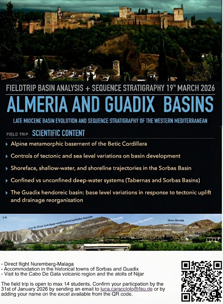
Practical Information
- Travel: Direct flight Nuremberg–Málaga
- Accommodation: Historical towns of Sorbas and Guadix
- Bonus excursion: Visit to the Cabo de Gata volcanic region and the atolls of Níjar
- Capacity: Maximum 14 students
Participants receive a comprehensive field guidebook with geological background, detailed stop descriptions, and exercises. The course combines field observations with evening discussions integrating outcrop data with published subsurface analogues.
Registration deadline: 31st January 2026
Contact:
Research topics fitting to both BSc and MSc thesis projects are always available and are largely focused on Sediment Provenance, Basin Analysis, Diagenesis and Reservoir Modelling.
Analytical tools include sedimentary petrography (thin section analysis and heavy minerals), detrital geochemistry (whole-rock and single-grain analysis) and mineralogy (XRD and Qemscan), geochronology (U-Pb dating) and compositional data analysis. Petrophysics (porosity, permeability, anisotropy and thermoconductivity), cathodoluminescence, micro-CT and Scanning Electron Microscope (SEM) and isotopic analyses are routinely applied for diagenetic studies. PETREL and similar software are also available for sedimentological, diagenetic and reservoir modelling.
Please contact me at: luca.caracciolo(at)fau(dot)de
- Permo-Triassic of South-East Germany (Bavaria) – up to 5 BSc and MSc thesis
We’re conducting research on both sediment provenance and diagenesis aiming at establishing the relationship between sediment supply, sedimentary environments and their influence on diagenetic processes and petrophysical properties. Permo-Triassic successions are studied from both outcrop and boreholes which will ultimately provide the opportunity to correlate correspondent formations at a regional scale. The analytical workflow includes core-logs analysis, petrophysics, diagenesis, sediment provenance and sedimentological/reservoir modelling. - Namibia (Southern Africa) – 3 thesis
On-going research in Namibia is focused on modern and ancient aeolian vs fluvial processes aiming at achieving a better understanding of dominant sedimentary dynamics in the Namib Desert over the last 15 Ma. Analytical workflow comprises bulk petrography and heavy mineral analysis, detrital geochemistry and possibly geochronology for the study of three formations, namely the Oswater, Karpfen Kliff and Langen Heinrich post-Miocene successions. - Betic Cordillera (South-western Spain) – 1 thesis
A provenance-basin analysis project based on bulk petrography and heavy mineral analysis to reconstruct drainage modifications in response to major tectonic events during the Serravalian-Tortonian building phase of the Betic Cordillera.