RV Meteor – Cruise M113 Azoren Plateau (2015)
RV Meteor – Cruise M113 Azoren Plateau
The Azores are a group of islands consisting of a large number of young and partially active volcanoes. The volcanic islands are located on the Azores Plateau, an area with thickened oceanic crust that is believed to have been formed by massive submarine volcanism 5 to 10 million years ago. The aim of the M113 expedition is to investigate the volcanic and tectonic structures of the Azores Plateau using seismic methods, to survey the plateau for the first time with multibeam echo sounders, and to take rock samples on the Azores Plateau. Scientists from the GZN are on board to examine the rock samples and, together with geophysicists from the University of Hamburg, develop a model for the causes of the extensive volcanism in the Azores.
4th weekly report, January 22, 2015
At the beginning of the week, Captain Schneider celebrated his 65th birthday. His special day was celebrated in style, and it was our pleasure and duty to congratulate him warmly.
The petrological program for the day was very successful, with numerous samples collected. Several TV grabs and push tube stations were operated west and southwest of Faial Island, providing us with insights into the distribution of recent volcanic and tectonic activity on the Azores Plateau. Not only were basalts and fresh glasses found, but also a variety of biogenic and clastic sediments. After a short transit, we took samples at three stations on the flanks of the João de Castro seamount, which exhibit a wide variety of rocks. North of the volcano, we found fresh, unaltered volcanic glass, while to the northwest, we found a variety of rock types that may be attributable to a debris flow. The last grab station of this trip was then driven northwest of Terceira. After the grab was completed, the final grab essentially contained stratified deep-sea clays, which, at least on board, gave no indication of magmatic activity in the vicinity.
In addition to sediment samples from the seabed, water samples were collected at selected locations during the expedition. These locations were chosen so that the smallest plastic particles, which enter the oceans through the decomposition of plastic bags, cosmetics, or washing machine wastewater, for example, could be quantified and characterized. Since the accumulation of microplastics and nanoplastics in the oceans goes hand in hand with an increase in toxins, there is a clear need for research into their concentration in water and their transport routes.
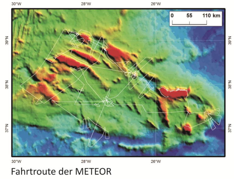
The final area of work for the reflection seismic program was located at the southwestern corner of the Azores island of Pico. Our profiles from previous weeks provided clear indications that the volume of a submarine landslide caused by the break-off of large blocks on the flanks of the island could well be around 50-100 cubic kilometers. We surveyed the upper slope with closely spaced profiles to better understand how the landslide is related to the movements of the tectonic plates and the underwater volcanoes. We used the last remaining hours for fan sounding mapping of the recently active Terceira reef. Today we completed the scientific research program directly in front of the port of Ponta Delgada – time for a first summary. To put it in numbers: we measured 89 reflection seismic profiles with a total length of more than 3500 km. TV grabs or the volcanic pipe were deployed at 29 positions. Since the port of Ponta Delgada borders directly on the measurement area, we recorded the data from the fan and sediment echo sounder from the beginning to the end of the trip, a total of 5700 km of usable data. However, a data volume expressed in numbers says nothing about its scientific relevance. We are confident that the evaluation phase will provide us with in-depth insights into numerous geological processes at work in the areas under investigation.
In summary, our data will enable us to gain a much better understanding of the significance of tectonic plate movements, volcanism, and submarine landslides for the development of the Azores archipelago. These processes do not occur independently; there is a clear interaction between them. For example, we find numerous volcanoes at all rift valleys because the faults extending through the Earth’s crust are weak zones that allow magma to rise. Volcanoes are also fragile structures, consisting of alternating layers of solidified and loose rock. This makes them sensitive to the influence of earthquakes or other forces. This can lead to large-scale landslides, which we actually found at most of the underwater volcanoes we studied. If these mass movements are rapid and massive, they can cause tsunamis. The dimensions and seismic images of almost all underwater volcanoes indicate explosive volcanism, which poses a further risk to the region.
The influence of the complex seafloor topography on seabed currents, as reflected in the sequence and geometry of the layers, will help to decipher the regional ocean circulation pattern. Last but not least, the numerous geophysical indications of gases or fluids present in and migrating through the seafloor contribute to our understanding of material cycles and exchange processes between the seafloor and the ocean.
Overall, we are observing cascading processes: tectonic plate movements cause rift valleys to form. Hot material from the Earth’s mantle, i.e. magma, rises through weak zones and causes volcanoes to form. The same forces that created volcanoes through rift formation destroy them again, because the accompanying tremors or tectonic plate shifts destabilize the flanks of the volcanoes and cause landslides and sometimes even tsunamis. The changes in the shape of the sea floor influence the ocean currents at the sea floor, which in turn affects the sedimentation patterns.
I would like to thank everyone on board for a successful trip; it was a great time in every respect.
All participants are safe and sound and send their regards home.
Christian Hübscher (tour leader M113)
3rd Weekly report, January 22, 2015
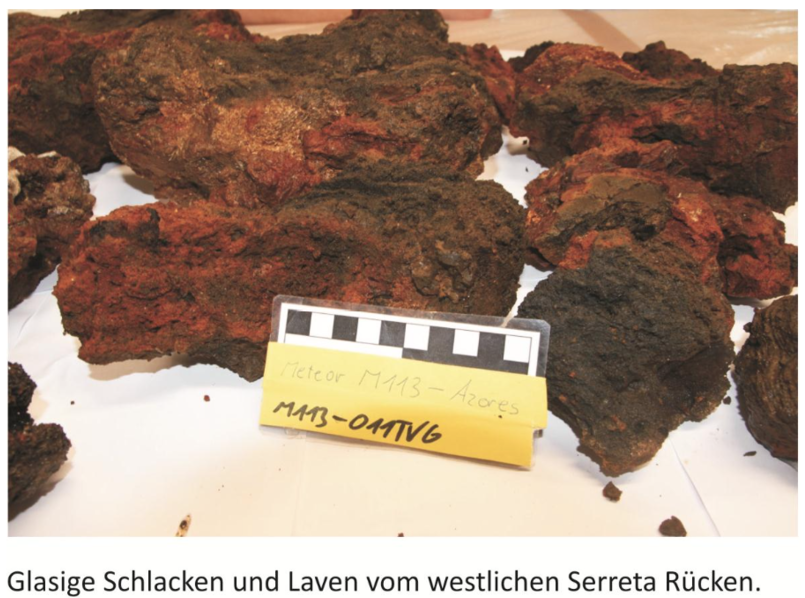
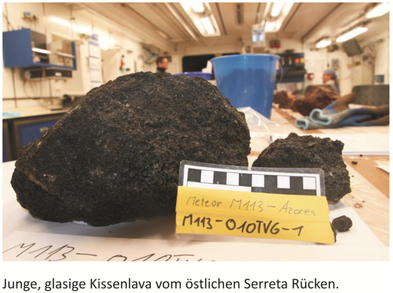
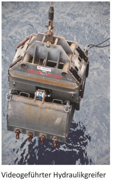
This week, we used the video-guided hydraulic grab to sample a magmatically very young ridge that extends into the sea west of the island of Terceira. This ridge was last active in the late 1990s, allowing conclusions to be drawn about the earlier phases of ocean island formation. Five of the six grab stations operated west of Terceira contained large quantities of very fresh volcanic glass, as well as pillow lavas that were obviously formed by exceptionally gas-rich eruptions. The lava from the two westernmost stations consists exclusively of very fresh pillow lava, whose cooling structures, glass rims, and degassing cavities serve as textbook examples and attracted the attention of everyone on board.
Two additional grab stations and a volcanic pipe were then moved west of Graciosa Island. Video recordings from the grabber reinforced indications of very recent volcanic activity west of Graciosa. The recordings showed glassy lava in this area, but unfortunately, successful grabber sampling was not possible, so the volcanic rock sampler was used for the first time in adverse weather conditions. Thanks to the excellent work of the deck crew, all equipment was brought back safely on board. The volcanic pipe contained mainly sandy deposits, but there are indications of fresh glass fragments from the surrounding lava fields. The last grab near Graciosa also showed young lava fields, but the grab tipped over during its last attempt and contained only a carbonate crust when it was successfully brought back on deck.
The geophysical measurements focused on the western part of the archipelago. We began by investigating the youngest segment of the active Terceira Rift in the northwest and gradually worked our way toward the southwest, where older rift valleys, volcanoes, and mass movements shape the complex topography of the seafloor—that is, the bathymetry. It became apparent time and again that interpreting the bathymetry without knowledge of the deeper structures beneath the seafloor can be misleading. Areas that would be interpreted as reworked sediment masses based solely on bathymetry turn out, when seismic data is taken into account, to be volcanic structures, and volcanoes interpreted from seismic data turn out to be slid sediment blocks.
We constantly adapt our travel plans to the latest findings. This can be done at very short notice, as we not only record data around the clock, but also process it to such an extent that we can visualize and evaluate it shortly after completing a measurement section. The discussions and resulting plans thrive on the interdisciplinarity and diversity of the group. The international nature of the research group strengthens the scientific and operational relationships between the participating institutes in Hamburg, Erlangen, Lisbon, Athens, and Paris at a time when marine research at the European level is imperative. The younger students contribute admirably to all departments with their intelligent questions, ideas, and energy; the older students guide them, and doctoral students take on key responsibilities. Our outstanding technicians take great care of our mechanical and electronic equipment.
This largely frees up senior scientists for planning tasks.
All participants are safe and sound and send their regards home. Christian Hübscher and Christoph Beier
2nd Weekly report, January 12, 2015
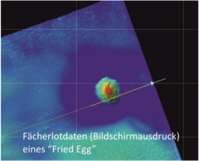
The week began with the discovery of circular structures on the sea floor, which the press informally referred to as “fried egg” structures. At the 2009 annual meeting of the American Geophysical Union (AGU), scientists
speculated that these are craters formed by meteorite impacts around 17 million years ago (see en.wikipedia.org/wiki/- Fried_Egg_struture). We took the time to map these interesting formations using hydroacoustic and seismic data. We can now rule out the possibility that they are meteorite impact structures. We are still discussing various alternative models here on board, but we are optimistic that we will soon understand how these striking structures were formed.
The southeast coast of Pico Island, with its mighty 2351 m high volcano Ponta do Pico, has steep, curved flanks that were created by the sliding of large sections of the slope. In order to assess whether these landslides triggered tsunamis, we measure the resulting deposits on the seabed using our imaging techniques. Depending on the characteristics of the blocks transported downhill, we will be able to determine the volume of the landslide material, the dynamics of the transport process, and the recurrence rate. One difficulty is foreseeable, however, as it is often not easy to distinguish landslide blocks from parasitic volcanoes, i.e., ash cones, which are numerous on the submarine flanks of Pico.
In order to gain a deeper understanding of the structural development of the Azores archipelago and the connection between tectonic plate movements and volcanism, it was necessary to compare a rift valley in the southwest of the archipelago, which is several million years old, with the currently active Terceira Rift. Such rifts are formed by tectonic stretching, usually at existing weak zones. The data show a recurring process: the early phase of stretching is accompanied by volcanism; these volcanoes can still be found on the rift shoulders today. A second, more intense volcanic phase begins once the rift has already opened. Fissure eruptions form elongated ridges that can tower several hundred meters above the rift shoulders, which are several kilometers apart.
1st Weekly report, January 8, 2015
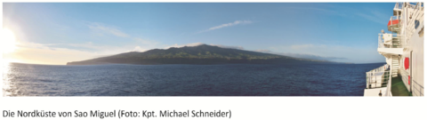
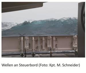
The scientists participating in the upcoming expedition arrived in Sao Miguel on the evening of December 28 and were taken directly to the ship by the agency. Captain Schneider and his crew gave them their usual warm welcome. Two weeks earlier, an advance team had installed the essential deck equipment, but there was still a lot to do in the laboratories. Computers and measuring instruments had to be set up, and the work continued late into the night. After a thorough safety briefing the next morning, we left the port of Ponta Delgada at 10 a.m. The weather was extremely poor, with rain and wind whistling around our ears even in the harbor. So it came as no surprise to the experienced passengers when the ship began to pitch and roll directly behind the harbor pier. The original plan to carry out the work south of the island had to be abandoned due to heavy seas, and we sailed to the north side of the island.
Using the ship’s hydroacoustic systems and seismic equipment, we mapped the outer shelf and upper slope of the island. The aim was to identify a possible connection between the channels discovered on the seabed five years ago and the water furrows on the flanks of the island’s volcanoes. This work was successfully completed on the first night on board. We now know that volcanic deposits from the island are transported downhill via the water furrows on land and the submarine channels and deposited on the seabed at distances of several tens of kilometers. This refuted another theory, according to which the channels are formed by deflected turbidity currents that transport suspended sediment from the northwest of the archipelago to the north coast of Sao Miguel.
Although all participants had survived the first night on board well, we were naturally delighted with the sunny, warm, and relatively windless weather of the following days. Subsequent geophysical measurements provided us with further insights into a wide variety of sediment transport processes, such as turbidity currents, landslides, and flow-controlled sedimentation; as well as into the tectonic fragmentation and widespread underwater volcanism south of São Miguel.
Four stations with the video-guided hydraulic grab were successfully operated on December 31, 2014, on the eastern edge of the Azores Plateau east of Formigas Bank. Sampling shows that the volcanoes in this area are apparently no longer active. The presence of partly rounded components in the sediments indicates shallow marine erosive processes. On January 3, 2015, the grab was used again on a topographic elevation in the western part of the Azores Plateau. The images show striking break-off edges of smaller carbonate platforms. Pelagic sediments are mainly deposited in smaller topographic depressions. The grab contained a block of biogenic carbonate measuring approximately 50x30x40 cm with bryozoans, corals, and sponge fragments. In later samples from the Princessa Alice Bank, there were no indications of igneous rocks.
Since the measurements began immediately after departure, the first few days were very dynamic. The interaction between the crew and the scientists was professional, effective, and pleasant from the outset, enabling us to achieve all of our interim goals in full. On New Year’s Eve, the crew had decorated the meeting room beautifully, and the cooks and stewards spoiled us with delicacies. The celebration helped us get to know each other better, and by the end of this first week, everyone had settled in wonderfully.
All participants are safe and sound and send their regards home.
Christian Hübscher (tour leader M113)
Research vessel Meteor
Cruise M113 (December 28, 2014 – January 4, 2015)
Azoren Plateau
Tour Leader: Prof. Dr. Chr. Hübscher, University of Hamburg
Crew Erlangen:
Dr. Chr. Beier
Dipl. Geol. Chr. Weinzierl
B. Schleifer